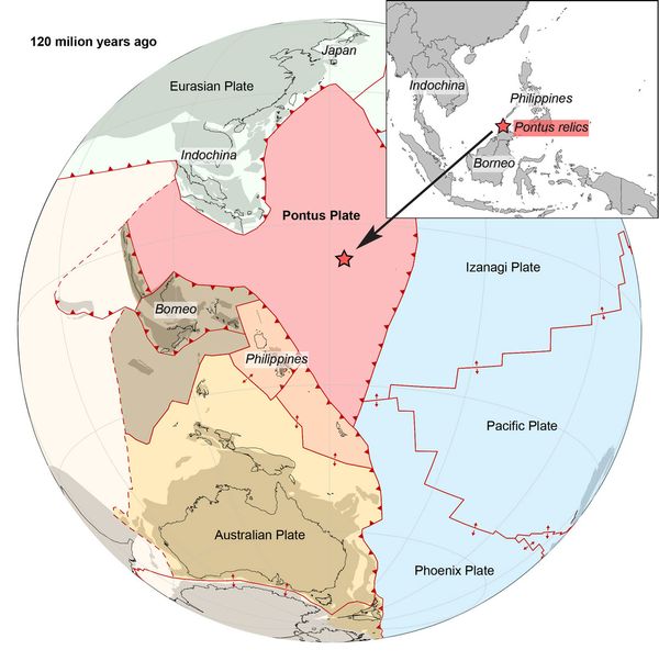
About 150 million years ago, a massive tectonic mega-plate stretched across the Earth, spanning roughly a quarter of the size of the Pacific Ocean. Its jagged contours ran all the way through the South China Sea and the intricate underpinnings of the Philippines, right up to the southern edge of Japan and northern shores of Borneo. Then, as the roiling layers of soft core-mantle shifted beneath the Pangaea supercontinent 20 million years ago, a smaller plate beneath Australia converged with a more northern Eurasian one — and between the two, the tectonic mega-plate disappeared.
For the past decade, the mega-plate was only called a theory. But when geologist Suzanna van de Lagemaat published her discovery this month, she proved that after its 20-million-year disappearance, the long-lost plate was real. Now we call it the Pontus Plate — a name chosen by she and her Utrecht University team after the primordial Greek sea god, and the former Pontus Ocean once atop the plate.
Published in the journal Gondwana Research, the study charts Van de Lagemaat’s discovery through a notoriously difficult reconstruction process in the most geologically complicated place on the planet.
"The Philippines is located at a complex junction of different plate systems,” Van de Lagemaat explained. “The region almost entirely consists of oceanic crust, but some pieces are raised above sea level, and show rocks of very different ages."
By reading the information stored in the rock’s ancient magnetic field, Van de Lagemaat was able to deduce what latitude the rock formed at.
Van de Lagemaat couldn’t just reach into the sea for a fistful of rocks to prove Pontus was real and as massive as predicted. To find remnants from a missing oceanic tectonic plate — as opposed to one, say, where human cities exist today — she had to dig into mountain belts in five countries to unearth ancient fragments in a bid to track the plate’s movement. And that’s how she found something rather odd.
 The Pontus oceanic plate that was reconstructed by Suzanna van de Lagemaat: its location in the paleo-Pacific ocean 120 million years ago, and its present relicts. (Suzanna van de Lagemaat, Utrecht University)
"We also conducted field work on northern Borneo, where we found the most important piece of the puzzle. We thought we were dealing with relics of a lost plate that we already knew about,” she said.
Those relics came in the form of a particularly telling mineral — basalt. The product of basaltic lava flows dating back more than 135 million years, basalt’s formation process is shaped by the natural magnetic fields present in its location at the time. By reading the information stored in the rock’s ancient magnetic field, Van de Lagemaat was able to deduce what latitude the rock formed at.
Want more health and science stories in your inbox? Subscribe to Salon's weekly newsletter Lab Notes.
“But our magnetic lab research on those rocks indicated that our finds were originally from much farther north, and had to be remnants of a different, previously unknown plate," she told Urecht University.
To suss out the trail of the moving plate and further identify the rock fragments, Van de Lagemaat turned to seismic topography and 3D modeling. When the edge of two tectonic plates shift to produce an earthquake, the seismic waves it emits are measured by seismographs all over the world. When calculating a waves’ speed and distance, a wave that shows up later than expected can point scientists toward previously undiscovered variations in the Earth’s mantle.
These seismic anomalies — a pool of data gathered from years upon years of earthquakes — are what Van de Lagemaat used to construct a 3D model of the area.
Pontus: reconstruction of a previously unknown tectonic plate in the paleo-Pacific Ocean
"Eleven years ago, we thought that the remnants of Pontus might lie in northern Japan, but we'd since refuted that theory," said Douwe van Hinsbergen, Van de Lagemaat's former Ph.D. supervisor. "It was only after Suzanna had systematically reconstructed half of the Ring of Fire mountain belts from Japan, through New Guinea, to New Zealand that the proposed Pontus plate revealed itself, and it included the rocks we studied on Borneo."
We need your help to stay independent
Oceanic crust is heavy stuff, geologically speaking, and that’s what Pontus was mostly made of. By the time the comparatively less dense crust of the Australian and Eurasian plates began shifting together during the early expansion of the Pacific ocean, Pontus’ density would have set it up to lose the battle against the encroaching plates.
By carefully piecing together the fragments of Pontus from the chipped edges of tectonic plate collisions (i.e. mountain formations) across the south Asian and Pacific regions, Van de Lagemaat proved the vast scope of Pontus and settled its disappearance once and for all.
Her work shows that as gravity battled against the buoyancy of Earth’s shifting mantle, Pontus was ultimately forced beneath the lip of the Eurasian tectonic plate — losing its fight for surface visibility in the process of subduction, being pulled down into the depths, and leaving only the scrapes of fragmentary evidence in the mountains marking its battle.


Shares